Sunday, April 7, 2013

Better later than never...


Today was a little warmer than we are used to.  The sky was rather cloudy and today it did rain just a little bit ago.  The previous days were had some rainy weather especially on Saturday.  Before that though the weather was not too exciting.  The high pressure area was upon us and that led to clear skies and cooler temps.  Then the low pressure area entered the equation   This led to some rain on Saturday and some today with the moisture in the clouds to bring precipitation.    


This current conditions are brought to you by AccuWeather.com!

Temperature: 38 degrees F
Wind: 0 mph from the North
Real Feel: 43 degrees F
Dew point: 33 degrees F.
Cloud Cover:  100%
Precipitation: none
Barometric Pressure: 29.85 in.


The wind map below shows the wind blowing from the East compared to AccuWeather stating that the wind is blowing from the North.  


The low pressure area is directly overhead and the larger amount of moisture is coming along with it.


The winds at 500 mb are showing the system with rain moving from the West and its predicted direction in the next few hours at least.


Here is the jet stream and the latitudinal lines across the U.S. will bring only smaller storms to our area and nothing too exciting.  There is however, a large low pressure area in the West coast that we could see some impact from later on.


Thursday, April 4, 2013

what the people of EC deserve!

As I was walking to class there was very little wind but the few bursts of air seemed to be coming from the West.  The clouds were wispy indicating cooler temperatures and the clouds were higher in altitude.      The weather for the next few days should be relatively similar to today.


This current conditions are brought to you by AccuWeather.com!

Temperature: 41 degrees F
Wind: 13 mph from the South West
Real Feel: 36 degrees F
Dew point: 30 degrees F.
Cloud Cover:  85%
Precipitation: none
Barometric Pressure: 30.03 in.


With the current maps posted below it seems that precipitation will be less likely as time passes.  The High pressure area is creeping down from Canada and the cold air along with it.


The map below shows the air flows at 500 millibars.  This map is great to use to forecast upcoming temps and where systems could travel to.  500 mb is a little closer to the surface than the jet stream.  The jet stream is roughly at the 300 mb mark.  Comparing the maps the high pressure should continue and there is also little moisture in our area for the time being.    


Tuesday, April 2, 2013

"This the end my only friend" - The Lizard King

Very few clouds with high cirrus clouds wispy across the sky.  The fuzzy clouds mean that there are cold temperatures in the area.  That makes sense with the high pressure are above.


This current conditions are brought to you by AccuWeather.com!

Temperature: 25 degrees F
Wind: 9 mph from the West
Real Feel: 23 degrees F
Dew point: 14 degrees F.
Cloud Cover:  0%
Precipitation: none
Barometric Pressure: 30.31 in. and increasing


Monday, April 1, 2013

what comes to pass...

The weather today was a little chilly but also the sun was shining.  The high pressure area was directly over head and allowed a great deal of sunlight in.  As I observed the clouds there were few to observe but many small humorous were scattered about the sky.


This current conditions are brought to you by AccuWeather.com!

Temperature: 28 degrees F
Wind: 12 mph from the West
Real Feel: 16 degrees F
Dew point: 13 degrees F.
Cloud Cover:  0%
Precipitation: none
Barometric Pressure: 30.19 in. and increasing


The current jet stream is not too exciting and showing some cooler air brushing by us.  


High pressure area overhead with the cold front down south currently.  Its like a large cool air mass from the North sweeping over the United States!


The radical wind map blowing cooler air from the West North West.


Sunday, March 31, 2013

Where does the time go?

Today, it did snow for some of the day but not as much as predicted.  The snow mostly came around 1 for about ten minutes.  The temperatures were warmer as well.  Most of the day was partly cloudy with  bursts of sun shine.
This is also very strange experiencing rain one day and then the next day it snows.


This current conditions are brought to you by AccuWeather.com!

Temperature: 29 degrees F
Wind: 0 mph
Real Feel: 19 degrees F
Dew point: 20 degrees F.
Cloud Cover:  0% with dense fog visibility 0 miles
Precipitation: not even an inch
Barometric Pressure: 29.82 in. and increasing


 High pressure means that no snow likely tomorrow! or for the next few days.

Saturday, March 30, 2013

O Rainy days

Todays weather fixated on the a great deal of precipitation.  Rained a good amount of the day and was quite foggy.  The low pressure area from the South was pushed North into our area and pushed the moisture as well.  The forecast for tomorrow could be very cold with a chance of flurries throughout the day.


This current conditions are brought to you by AccuWeather.com!

Temperature: 34 degrees F
Wind: 0 mph
Real Feel: 37 degrees F
Dew point: 32 degrees F.
Cloud Cover:  20% with dense fog visibility 0 miles
Precipitation: none today
Barometric Pressure: 29.82 in. and decreasing


Friday, March 29, 2013

Friday Fish Fry with a side of tartar

The weather has taken a turn into a more cloudy sky almost completely covered.  AccuWeather states that it is 100% cloud cover but where I am it is a little patchy in some areas.  The clouds and the lower barometric pressure could mean some precipitation tomorrow or the next day.


This current conditions are brought to you by AccuWeather.com!

Temperature: 39 degrees F
Wind: 0 mph
Real Feel: 49 degrees F
Dew point: 20 degrees F.
Cloud Cover:  100%
Precipitation: none today
Barometric Pressure: 30.32 in.

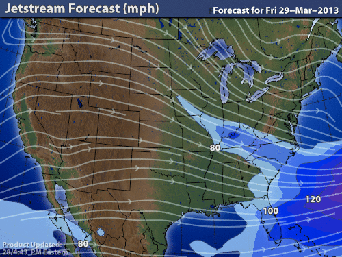
The low pressure area to the West  of us is what we want to watch out for.  That would be where any precipitation would come from if we got some.  The wind and jet stream would perpetuate this precipitation.  For today the weather should be calm and warmer temperatures.

This would bring that low pressure area to the EC area.  However, it is not the strongest low pressure area so the rain could be very minimal.


Curent surface winds from Hint.fm.  This map varies from AccuWeather in that the current surface winds are blowing from the South which could heighten our chances for precipitation 


The water vapor in the atmosphere is also not that significant to the West of us which also diminishes the precipiation that we could get.  If we got a strong South wind we could get some rain from the low pressure are to the South of us.  But there is a slim chance of that.