
Tuesday, May 7, 2013
Monday, May 6, 2013
guessing!
The weather was wonderful today! The sun was shining with high cirrus clouds in the sky very wispy meaning that the clouds are so high that they have small ice crystals giving them the appearance of wispy. The sunset was a pretty site I regret not getting a picture. However, the temp should remain consistent for the next few days and hope it stays!
This current conditions are brought to you by AccuWeather.com!
Temperature: 56 degrees F
Wind: 0 mph from the North West
Real Feel: 59 degrees F
Dew point: 42 degrees F.
Cloud Cover: 100%
Barometric Pressure: 30.02 in.
The high pressure area is still here so not much change in the weather for awhile.
 I mainly added this for the sweet design that is located over South Dakota. The pattern is following the high pressure area that is centered right there.
Here is the 500 mb height and this shows where our temps our gona be from wiht the 60 and 70s tomorrow.

This current conditions are brought to you by AccuWeather.com!
Temperature: 56 degrees F
Wind: 0 mph from the North West
Real Feel: 59 degrees F
Dew point: 42 degrees F.
Cloud Cover: 100%
Barometric Pressure: 30.02 in.
The high pressure area is still here so not much change in the weather for awhile.


Here is the 500 mb height and this shows where our temps our gona be from wiht the 60 and 70s tomorrow.

Sunday, May 5, 2013
The best is yet to come
The weather was sunny and only partly cloudy. When I was outside the air was warm and the wind was only slightly blowing.
This current conditions are brought to you by AccuWeather.com!
Temperature: 53 degrees F
Wind: 3 mph from the North East
Real Feel: 53 degrees F
Dew point: 44 degrees F.
Cloud Cover: 100%
Barometric Pressure: 30.07 in.

Tomorrow's weather should be pretty nice with some warmer temperatures and little clouds in the sky. The current jet stream is showing the warmer Southern air will be the reason for our warmer temps. The high pressure area is also going to impact our weather with some sun and warmer temps.

Here is the upper air data at the 500 mb height which has the low pressure area in the South and then not too exciting over us right now.

The surface winds here is showing the high pressure area over us.

This current conditions are brought to you by AccuWeather.com!
Temperature: 53 degrees F
Wind: 3 mph from the North East
Real Feel: 53 degrees F
Dew point: 44 degrees F.
Cloud Cover: 100%
Barometric Pressure: 30.07 in.

Tomorrow's weather should be pretty nice with some warmer temperatures and little clouds in the sky. The current jet stream is showing the warmer Southern air will be the reason for our warmer temps. The high pressure area is also going to impact our weather with some sun and warmer temps.


The surface winds here is showing the high pressure area over us.

Saturday, May 4, 2013
day after day... the weather keeps a comin
The recent days have shown us portions of every season. We had a weekend of super warm temperatures and then rain came and then a blizzard and then some cooler winds. The last portion reminded me of a fall day.
Today was partly cloudy with buildings and curbs have water running about them. The temperatures should warm up now and summer should finally be here.
This current conditions are brought to you by AccuWeather.com!
Temperature: 48 degrees F
Wind: 5 mph from the North
Real Feel: 52 degrees F
Dew point: 38 degrees F.
Cloud Cover: 100%
Barometric Pressure: 30.12 in.
The jet stream is showing a very strong low pressure area in the Southern United States which is producing strong storm in there as well.
 This current surface map shows those storms in the South and a little bit of precipitation to the North of Wisconsin. Since the wind is coming from the North and the 500 mb map also shows a upper air flow blowing from the North so the rain could hit us later tonight. It was predicted by AccuWeather that the Eastern portion of the U.S. will have strong storms throughout the spring and summer months and so far that is holding true. The low pressure area is massive.


Today was partly cloudy with buildings and curbs have water running about them. The temperatures should warm up now and summer should finally be here.
This current conditions are brought to you by AccuWeather.com!
Temperature: 48 degrees F
Wind: 5 mph from the North
Real Feel: 52 degrees F
Dew point: 38 degrees F.
Cloud Cover: 100%
Barometric Pressure: 30.12 in.
The jet stream is showing a very strong low pressure area in the Southern United States which is producing strong storm in there as well.


Thursday, May 2, 2013
Live life to the fullest!
Well it turned out that the snow came in full force. I was wrong about how much though. It will continue tonight and perhaps into tomorrow morning. Then should be a tad better weather.
This current conditions are brought to you by AccuWeather.com!
Temperature: 32 degrees F
Wind: 8 mph from the North
Real Feel: 23 degrees F
Dew point: 31 degrees F.
Cloud Cover: 100%
Barometric Pressure: 30.48 in. and decreasing
Look at that storm flowing like a river right over us...a blunt hit to the face with snow on May 2nd.
Oooo this will last most of the day and into tomorrow that is a big bummer.

Here is the jet stream and the colder air should keep coming for awhile at least until this weekend is over.

True...True
The weather has turned down. The rain came around 4 o'clock and continued all night and turned to a light sleet and the temperatures dropped as well. When I was coming home from class and the wind was blowing strong from the North.
This current conditions are brought to you by AccuWeather.com!
Temperature: 34 degrees F
Wind: 9 mph from the North
Real Feel: 21 degrees F
Dew point: 34 degrees F.
Cloud Cover: 100%
Barometric Pressure: 30.43 in. and decreasing
The jet stream bring the colder air. Tonight the snow has a good chance to accumulate if the temps stay cooler. But a good amount of rain should come if it is not snowing.

The high pressure area is bringing the snow on a track coming towards right towards us.
 Here is the 500 mb height and is should bring cooler temps tomorrow and no precipitation should occur tomorrow for sure in the afternoon.


This current conditions are brought to you by AccuWeather.com!
Temperature: 34 degrees F
Wind: 9 mph from the North
Real Feel: 21 degrees F
Dew point: 34 degrees F.
Cloud Cover: 100%
Barometric Pressure: 30.43 in. and decreasing
The jet stream bring the colder air. Tonight the snow has a good chance to accumulate if the temps stay cooler. But a good amount of rain should come if it is not snowing.

The high pressure area is bringing the snow on a track coming towards right towards us.


Tuesday, April 30, 2013
HAAAZAA! 900 views on the weather blog
The weather today started off with a tad bit of rain and then turned into a fairly nice day with sunshine and little cloud cover. Then around 900 pm it rained again. Just some light showers so not too bad.
This current conditions are brought to you by AccuWeather.com!
Temperature: 656 degrees F
Wind:16 mph from the South East
Real Feel: 52 degrees F
Dew point: 51 degrees F.
Cloud Cover: 100%
Barometric Pressure: 29.85 in. and increasing
The next few images show are great for what we are experiencing. The jet stream is going to be sweeping down through the middle of the country and cooling the temperatures as well.

This is the current surface map and the storms are rolling through and following behind the cold front.

The 500 mb height is showing the flow of wind right over us. Bringing in the precipitation tonight and perhaps until tomorrow midmorning.

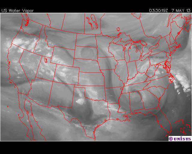
Here is the moisture that is over us.

This current conditions are brought to you by AccuWeather.com!
Temperature: 656 degrees F
Wind:16 mph from the South East
Real Feel: 52 degrees F
Dew point: 51 degrees F.
Cloud Cover: 100%
Barometric Pressure: 29.85 in. and increasing
The next few images show are great for what we are experiencing. The jet stream is going to be sweeping down through the middle of the country and cooling the temperatures as well.

This is the current surface map and the storms are rolling through and following behind the cold front.

The 500 mb height is showing the flow of wind right over us. Bringing in the precipitation tonight and perhaps until tomorrow midmorning.

Here is the moisture that is over us.

Subscribe to:
Posts (Atom)