
Monday, March 4, 2013
whoo 2nd post of the day.
Well didn't notice the trend of the clouds. The eastern and southern winds usually do bring strong storms The low pressure area will also help the large storm with allowing a great deal of snow to accumulate. The image below will give a nice visual of the current weather in our area.


Sunny side up with a snow cone!
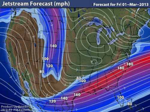
Today is a day where snow is on the rise or should I say on the sun set. AccuWeather states that our area is a risk for some snowfall later tonight to later tomorrow. The projected amount of snow for our area is 3 top 6 inches. The Low pressure area that is to the West of us does have the potential for a good amount of snow. The Jet stream in an image below shows the wind blowing East which could push that low pressure are toward us. The infrared satellite image has a great deal of moisture within it.


Temperature: 24 degrees F
Wind: 4 mph from the South East
Real Feel: 17 degrees F
Dew point: 10 degrees F.
Cloud Cover: 100%
Precipitation: none so far
Barometric Pressure: 30.07 and decreasing
My forecast from the other day was not too far off we did not get snow yet and the temps did get colder today.
Sunday, March 3, 2013
clear skies, sunny and share!
The weather has been in a funk and it has been rather boring. Today was accurately predicted by my former post. The warm front has dissipated and currently there is a stagnant front to the West of us. The two images below demonstrate what is occurring. There is little wind outside and there are no clouds in the sky.


This current conditions are brought to you by AccuWeather.com!
Temperature: 27 degrees F
Wind: 4 mph from the East
Real Feel: 43 degrees F
Dew point: 8 degrees F.
Cloud Cover: 0%
Precipitation: none
Barometric Pressure: 30.15 and decreasing
The barometric pressure is decreasing slowly, therefore a storm could accumulate especially with the moisture to the west of us.


This current conditions are brought to you by AccuWeather.com!
Temperature: 27 degrees F
Wind: 4 mph from the East
Real Feel: 43 degrees F
Dew point: 8 degrees F.
Cloud Cover: 0%
Precipitation: none
Barometric Pressure: 30.15 and decreasing
The barometric pressure is decreasing slowly, therefore a storm could accumulate especially with the moisture to the west of us.
Saturday, March 2, 2013
The high pressure experience!
Yes once again the the high pressure area is upon us and as tribute to that...Jimi Hendrix.
And the weather today is pretty much awesome! Th sun is shining and there are very few clouds in the sky. The high pressure are is over head and with a sweatshirt its manageable to go outside. The clouds are wispy and not too dense blowing from the North.
This current conditions are brought to you by AccuWeather.com!
Temperature: 19 degrees F
Wind: 6 mph from the North
Real Feel: 21 degrees F
Dew point: 10 degrees F.
Cloud Cover: 0%
Precipitation: none
Barometric Pressure: 30.35 and rising
The forecast for tomorrow could include some snow. The warm front that is in the West could move toward our area. However, the wind is blowing from the North and this could direct that warm front away from us. The map shows that there is little wind in our area.

Here is a wind map from hint.fm
Its a nice view of the precise split in the wind directly where we are in Eau Claire. And that warm front to the West can be easily seen where the wind is directed to the North.


Here is a better visual of the warm front, which could bring some snow. This would cause the warmer air to cool and reach the dew point. This would then cause precipitation if there is enough moisture in the air.
To answer that we shall look at an infrared image. There is some moisture accumulating West of us so there is some possibility of precipitation in the near future. Ill keep ya updated. I do not believe it will amount to much if we do get some.

And the weather today is pretty much awesome! Th sun is shining and there are very few clouds in the sky. The high pressure are is over head and with a sweatshirt its manageable to go outside. The clouds are wispy and not too dense blowing from the North.
This current conditions are brought to you by AccuWeather.com!
Temperature: 19 degrees F
Wind: 6 mph from the North
Real Feel: 21 degrees F
Dew point: 10 degrees F.
Cloud Cover: 0%
Precipitation: none
Barometric Pressure: 30.35 and rising
The forecast for tomorrow could include some snow. The warm front that is in the West could move toward our area. However, the wind is blowing from the North and this could direct that warm front away from us. The map shows that there is little wind in our area.

Here is a wind map from hint.fm
Its a nice view of the precise split in the wind directly where we are in Eau Claire. And that warm front to the West can be easily seen where the wind is directed to the North.


Here is a better visual of the warm front, which could bring some snow. This would cause the warmer air to cool and reach the dew point. This would then cause precipitation if there is enough moisture in the air.
To answer that we shall look at an infrared image. There is some moisture accumulating West of us so there is some possibility of precipitation in the near future. Ill keep ya updated. I do not believe it will amount to much if we do get some.

Friday, March 1, 2013
got up and went straight to the blog...dedication
So the post from the other day was pretty accurate. The weather currently is partly cloudy and sunny. The clouds seem to be similar to yesterday, the altostratus clouds are covering the sky. However, the clouds seem to be more feathery and wispy. The wind is blowing from the North but not too vigorously.
This current conditions are brought to you by AccuWeather.com!
Temperature: 28 degrees F
Wind: 7 mph from the NorthEast
Real Feel: 28 degrees F
Dew point: 12 degrees F.
Cloud Cover: 0%
Precipitation: none
Barometric Pressure: 30.29 and rising
 The high pressure are is still overhead and this brought some cooler temperatures and less cloud cover. The infrared imagery directly below shows little moisture in the United States. Which would mean little precipitation in the near future.

The jet stream shows the wind direction of the high pressure area and the major curve in the jet stream from the Pacific.

This surface data plot shows a great deal of info. This map shows 2/8 cloud cover in Eau Claire which is different than AccuWeathers statement of clear skies. Also the stagnant front and wind direction as well as any moisture occurring.

The forecast for tomorrow will be partly cloudy skies no snow in the forecast and temperatures in low to mid 30's.
This current conditions are brought to you by AccuWeather.com!
Temperature: 28 degrees F
Wind: 7 mph from the NorthEast
Real Feel: 28 degrees F
Dew point: 12 degrees F.
Cloud Cover: 0%
Precipitation: none
Barometric Pressure: 30.29 and rising


The jet stream shows the wind direction of the high pressure area and the major curve in the jet stream from the Pacific.

This surface data plot shows a great deal of info. This map shows 2/8 cloud cover in Eau Claire which is different than AccuWeathers statement of clear skies. Also the stagnant front and wind direction as well as any moisture occurring.

The forecast for tomorrow will be partly cloudy skies no snow in the forecast and temperatures in low to mid 30's.
Thursday, February 28, 2013
Jeopardy in the clouds.
While walking to class the temperatures were mild and the wind was just blowing at low speeds what seemed to be coming from the behind me which would be the North. The cloud cover was 100% with a majority of altostratus cloud cover. the wind was blowing from the North so no storms would be coming anytime soon. While watching Jeopardy I noticed that the cloud cover was a thick blanket covering the sky.
Here is the wind map for the day from hint.fm

This current conditions are brought to you by AccuWeather.com!
Temperature: 29 degrees F
Wind: 9 mph from the North
Real Feel: 20 degrees F
Dew point: 21 degrees F.
Cloud Cover: 100%
Precipitation: none
Barometric Pressure: 30.06 and rising
The forecast that was posted yesterday was accurate. The high pressure area is located over head and the temperatures are mild to colder in the area. In store for the next few days are similar to today. The high pressure area will be over us for a while.

The jet stream will bring some warmer temperatures to the area and the with the extreme curve in the jet stream the possibility for a storm could come in the next few days.
The current water vapor content does not seem too amount to anything too substantial. Some of the largest content is in the Western United States.

This surface data plot shows a great deal of information. Similar to the wind map one can see the direction of the wind and whether or not precipitation is occurring. This also shows the stationary front to the West of Eau Claire.

Subscribe to:
Posts (Atom)