Thursday, March 21, 2013

whooo bo ganya!

The weather has been relatively stagnant in the past two days.  Simply cool and some breeze.  Some spotty clouds here and there could be the beginning of the storm process but with the current wind coming from the North not too likely.  Just some cooler temps likely for a few days.


This current conditions are brought to you by AccuWeather.com!

Temperature: 22 degrees F
Wind: 0 mph from the North West
Real Feel: 29 degrees F
Dew point: 7 degrees F.
Cloud Cover:  20%
Precipitation: none today
Barometric Pressure: 30.08 in. and increasing


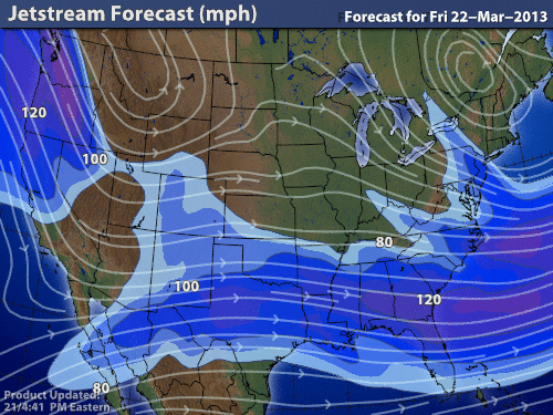
 Jet stream is relatively straight across therefore the temps are relative to latitude.


Tuesday, March 19, 2013

All quiet on the Cold Front

The sky is clear and that means its cold their is no blanket to keep everyone warm.  The heat is radiating away from the earth's surface.


This current conditions are brought to you by AccuWeather.com!

Temperature: 13 degrees F
Wind: 16 mph from the North West
Real Feel: -4 degrees F
Dew point: -2 degrees F.
Cloud Cover:  0%
Precipitation: none today
Barometric Pressure: 29.94 in. and increasing


Low pressure area is the trough once again in the jet stream.  The strong winds blowing from the North West should bring cooler temperatures for awhile.


Monday, March 18, 2013

All this snow and no time to play

Snow snow snow!


This current conditions are brought to you by AccuWeather.com!

Temperature: 27 degrees F
Wind: 9 mph from the South
Real Feel: 19 degrees F
Dew point: 25 degrees F.
Cloud Cover:  100%
Precipitation:
Barometric Pressure: 29.59 in. and decreasing

The storm is right over us as well as the low pressure area.  As I am posting this the snow stopped in my location and I am thinking that the storm will continue over night and perhaps some snow tomorrow. With total accumulation around 5- 7 inches.   The large amount of moisture to the South of us could bring more snow tomorrow.


Very nice surface data map from intellicast.com


Large amount of clouds and moisture to the South of Wisconsin.  Map from Intellicast.com


Winds sweeping from the South in our area and circling the low pressure area creating the trough.   


Sunday, March 17, 2013

Kris Kringle is upon us...

With the low pressure area seems to be coming in and there is also a strong wind coming from the east. The chance of a strong storm is highly likely.  And with the moisture in the area our area could get a good amount of snow.


This current conditions are brought to you by AccuWeather.com!

Temperature: 23 degrees F
Wind: 10 mph from the South East
Real Feel: 12 degrees F
Dew point: 11 degrees F.
Cloud Cover:  35%
Precipitation:  Zero
Barometric Pressure: 30.05 in. and increasing


Low pressure area with a good amount of moisture attached to it.  


One can see the trough of the low pressure area in the Dakotas.  


A great image from hint.fm.


Saturday, March 16, 2013

Ah... who are you!

Yesterdays weather was pretty intense!  A good amount of snow fell in the Eau Claire area.  The weather today cleared up and the sky is clear and sunny.  I did not think we would get as much snow as we ended up getting.  The snow was unbelievable.  Well today we have no worries.  The high pressure area is right over the top of us and no bad weather should happen today.  I am going to have to be careful with what I say. The weather has completely switched on very little notice.  There are no guarantees with the weather just trends that happen and trends can turn on a dime.   


This current conditions are brought to you by AccuWeather.com!

Temperature: 19 degrees F
Wind: 5 mph from the North
Real Feel: 26 degrees F
Dew point: 11 degrees F.
Cloud Cover:  20%
Precipitation:  around 3 to 5 inches
Barometric Pressure: 30.10 in. and increasing


 Hence the high pressure area right above us.


Thursday, March 14, 2013

Opulent sky!

Today the weather was pretty darn good!  We had a very sunny day and just a few clouds in the sky.  This was the start of the pattern for the a storm.  The low pressure area is moving toward us which could bring us a good amount of snow.  I believe the majority of the snowfall will not reach Eau Claire until mid-afternoon.  


This current conditions are brought to you by AccuWeather.com!

Temperature: 30 degrees F
Wind: 5 mph from the South West
Real Feel: 29 degrees F
Dew point: 24 degrees F.
Cloud Cover:  60%
Precipitation:  had a little
Barometric Pressure: 30.07 in.


The jet stream will cause the cold front and low pressure area to go right over us and this could turn into a light snow and the afternoon should bring the heavy dose of the snow.


The jet stream coming from the North will also bring cooler temperatures to our area.


The water vapor that is to the west has a good chance of precipitation tomorrow.


Wednesday, March 13, 2013

slipped my mind...

Hey yesterday was a busy day for me.   Therefore, I forgot to post about the weather.  The day yesterday was unique with a few flurries during the noon hour and then sunny skies the rest of the day.


This current conditions are brought to you by AccuWeather.com!

Temperature: 18 degrees F
Wind: 6 mph from the North West
Real Feel: 18 degrees F
Dew point: 4 degrees F.
Cloud Cover:  0%
Precipitation:  0  inches of snow
Barometric Pressure: 30.33 in.


The heat signature over the nation shows little moisture in our area.  As well as the high pressure area drives the cloud cover away.   Therefore, for the next few days will be calm and little if no snow.


The current wind is very low and no cloud cover in our area and no precipitation.  the Rocky Mountains are acting as a barrier to the stagnant front.

The jet stream will bring some cooler temperatures to our area from the continental polar air mass.