Tuesday, April 30, 2013

HAAAZAA! 900 views on the weather blog

The weather today started off with a tad bit of rain and then turned into a fairly nice day with sunshine and little cloud cover.  Then around 900 pm it rained again.  Just some light showers so not too bad.


This current conditions are brought to you by AccuWeather.com!

Temperature: 656 degrees F
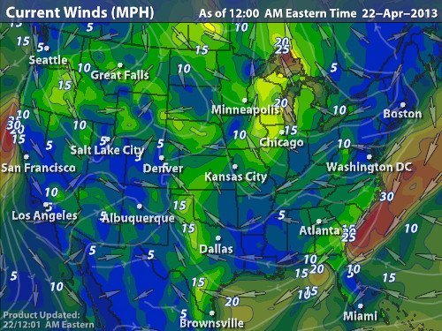
Wind:16 mph from the South East
Real Feel:   52 degrees F
Dew point: 51 degrees F.
Cloud Cover:  100%
Barometric Pressure: 29.85 in. and increasing


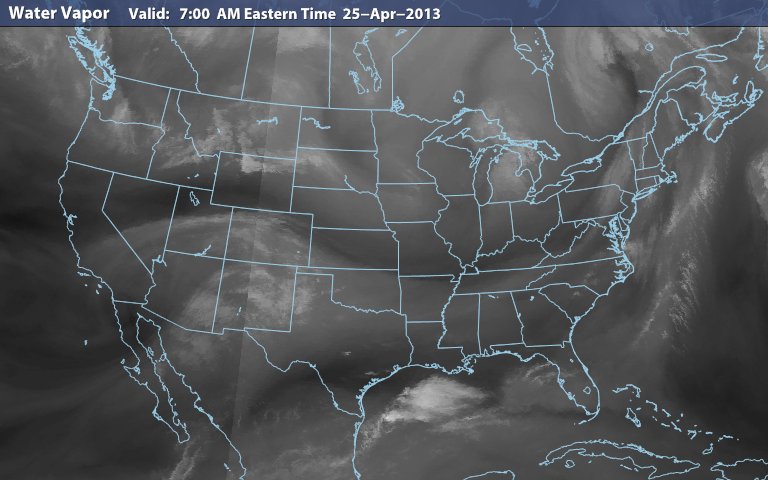
The next few images show are great for what we are experiencing.  The jet stream is going to be sweeping down through the middle of the country and cooling the temperatures as well.


This is the current surface map and the storms are rolling through and following behind the cold front.


The 500 mb height is showing the flow of wind right over us.  Bringing in the precipitation tonight and perhaps until tomorrow midmorning.  


Here is the moisture that is over us.


Monday, April 29, 2013

Sometimes ya just gota have fun with what ya got

All weekend long it was beautiful.  The rays of the sun warmed up all of EC.  Sunday night it rained briefly and then the next day was once again great.  Had to spend a great deal of time at work because of the nice weather.  But all is well and got some hours.


This current conditions are brought to you by AccuWeather.com!

Temperature: 68 degrees F
Wind:16 mph from the South
Real Feel:   64 degrees F
Dew point: 52 degrees F.
Cloud Cover:  0%
Barometric Pressure: 29.62 in.

Judging by the low pressure area in our vicinity, there is a chance that we could see some precipitation either tonight or tom.  The wind is coming from the South so little less chance for precipitation.  The upper air flows show little of rain but things can change.   


Friday, April 26, 2013

Hams the beer refreshing!

The sunny and little wind day brought out the party goers in the student Ghetto!


This current conditions are brought to you by AccuWeather.com!

Temperature: 51 degrees F
Wind: 0 mph from the North West
Real Feel:  54 degrees F
Dew point: 30 degrees F.
Cloud Cover:  0%
Barometric Pressure: 30.10 in.

There is a chance of a storm either tonight or tomorrow morning.  The precipitation to the West of us have a chance of hitting us if they persist.  However, very nice weather should persist if it doesn't happen or it will be nice after.  There also is a chance of cooler weather next week.


Thursday, April 25, 2013

Day before and walk

The day was pretty gorgeous! Sunny and partly cloudy for most of it.


This current conditions are brought to you by AccuWeather.com!

Temperature: 41 degrees F
Wind: 5 mph from the North West
Real Feel:  40 degrees F
Dew point: 36 degrees F.
Cloud Cover:  100%
Barometric Pressure: 30.18 in.

The Low pressure area to the North East of us is just about to end and the there could be a thunderstorm coming within the next few days.  Tomorrow, the high should around 50 and the day should be similar.


25 morn sun rise


Wednesday, April 24, 2013

County Road trip and fields of gold!

As I awoke this morning the sun shine through my blinds!  The day was, from that point, good!  The wind was low and the clouds were speckled across the sky.  As I examined the sky the clouds were blowing towards the North.


This current conditions are brought to you by AccuWeather.com!

Temperature: 48 degrees F
Wind: 13 mph from the South West
Real Feel:  40 degrees F
Dew point: 24 degrees F.
Cloud Cover:  100%
Barometric Pressure: 29.90 in.

There is a small chance of precipitation tonight with a low pressure area moving in but not too likely.  However, tomorrow should be a great day with a high around 50.

This surface map contains the wind direction in our area that could push the rain to our area but judging by the moisture in the last image it wont be too much.


Pics of sky on country


Tuesday, April 23, 2013

Fine wine...in a jug

The weather today started with


This current conditions are brought to you by AccuWeather.com!

Temperature: 31 degrees F
Wind: 3 mph from the West
Real Feel:  32 degrees F
Dew point: 22 degrees F.
Cloud Cover:  100%
Barometric Pressure: 30.06 in. and decreasing

The Weather seems to be clearing up.  The high pressure area is moving in and that should bring nice weather and warmer weather.  Looking through the layers of the the trough can be seen passing over Southern Wisconsin.  The cold and poor weather should be over at least for a while.  


The moisture moving through Southern Wisconsin and the distinct line of the rain that is visible.  


The jet stream and the trough present over North Dakota.  


View from above!

A 360 view from Phillips


Monday, April 22, 2013

Outside from Davies

Look at them clouds!


Fish out of Water!

Did anyone play that game as a kid? yea well I am stuck with no umbrella at school working on finishing up a paper so I am having the time of my life haha.  But regardless weather is happening and looks like a small storm could come our way tomorrow morning.


This current conditions are brought to you by AccuWeather.com!

Temperature: 39 degrees F
Wind: 7 mph from the North East
Real Feel:  35 degrees F
Dew point: 38 degrees F.
Cloud Cover:  100%
Barometric Pressure: 30.09 in. and decreasing


The precipitation is raining down the wrath of Poseidon!  The snow has a good chance of coming tomorrow morning with the jet stream bring the cooler air from the North and the low pressure area creeping up from the South West.  The wind coming from the North East is also not a very good sign when trying to get some nice weather up in here.  But a great deal of moisture is in the ground which is noce for the drought we had the last few years.  


This upper air data from the 500 mb level shows that low pressure area could creep up to us.


And this jet stream could force that low pressure area to get some cooler air and bring the snow we could see tomorrow if this persists.


Sunday, April 21, 2013

The Goo


The weather today was full of moisture.  A great deal of precipitation fell while I was hard at work on a paper.

This current conditions are brought to you by AccuWeather.com!

Temperature: 45 degrees F
Wind: 15 mph from the South
Real Feel:  32 degrees F
Dew point: 43 degrees F.
Cloud Cover:  100%
Barometric Pressure: 30.10 in. and decreasing

There is a chance of precipitation tomorrow but the temps should remain warmer with the latitudinal flow of the jet stream.


Friday, April 19, 2013

Continuation of the previous...


This current conditions are brought to you by AccuWeather.com!

Temperature: 28 degrees F
Wind: 3 mph from the North West
Real Feel:  29 degrees F
Dew point: 21 degrees F.
Cloud Cover:  0%
Barometric Pressure: 29.95 in. and increasing


Tomorrow should be very little snow with the high pressure area coming over us.

Yogurt and bi polar weather!

Today the weather was literally the strangest weather I have ever experienced . The weather would change in minutes from sunny and dry to a windy blizzard! Most of the day was spent working between homework and work but what I saw outside was amazing. I wish I could have taken a few pictures thinking back on the extreme differences. The best time of the day was later in the afternoon, the sun was shining and smaller and smaller blizzards were occurring. I did manage to get a picture of the sunset that I will have to post eventually. Currently the conditions are cooler temps and a bit of a breeze the sky is partly cloudy.

Thursday, April 18, 2013

Gas station trip!

The weather was kinda crappy the entire day with on and off precipitation throughout the entire day.  The sun did not come out and it was dismal.  The trip to the gas station was when the rain was pretty constant.


This current conditions are brought to you by AccuWeather.com!

Temperature: 32 degrees F
Wind: 8 mph from the North West
Real Feel: 23 degrees F
Dew point: 29 degrees F.
Cloud Cover:  100%
Barometric Pressure: 29.39 in.


The low pressure area is directly over head and there could be some precipitation tomorrow.  The next few days should be less precipitation.  The warm front would be the cause of the rain tomorrow.    

These are the upper data charts similar to last post.  The 925 mb shows the low pressure area and the trough  that has formed in the 500 and 300 mb levels.  This would bring the precipitation tomorrow if it presists.