Thursday, February 28, 2013

Jeopardy in the clouds.


While walking to class the temperatures were mild and the wind was just blowing at low speeds what seemed to be coming from the behind me which would be the North.  The cloud cover was 100% with a majority of altostratus cloud cover.  the wind was blowing from the North so no storms would be coming anytime soon.  While watching Jeopardy I noticed that the cloud cover was a thick blanket covering the sky.

Here is the wind map for the day from hint.fm


This current conditions are brought to you by AccuWeather.com!

Temperature: 29 degrees F
Wind: 9 mph from the North
Real Feel: 20 degrees F
Dew point: 21 degrees F.
Cloud Cover: 100%
Precipitation:  none
Barometric Pressure: 30.06 and rising

The forecast that was posted yesterday was accurate.  The high pressure area is located over head and the temperatures are mild to colder in the area.  In store for the next few days are similar to today.  The high pressure area will be over us for a while.


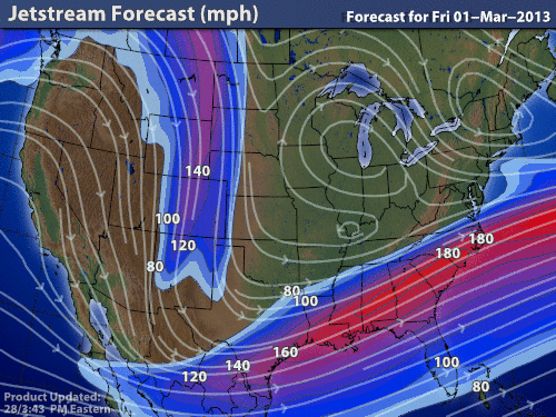
The jet stream will bring some warmer temperatures to the area and the with the extreme curve in the jet stream the possibility for a storm could come in the next few days.    


The current water vapor content does not seem too amount to anything too substantial.  Some of the largest content is in the Western United States.


This surface data plot shows a great deal of information.  Similar to the wind map one can see the direction of the wind and whether or not precipitation is occurring.  This also shows the stationary front to the West of Eau Claire.


Wednesday, February 27, 2013

Riders on the Storm! (the Doors of Perception)

Well well my forecast from the yesterday was a tad accurate and a tad off.  I realized I was not very thorough on my last post.  The snow did come today around 1:00 pm.  However, it did not accumulate to much at all.  While walking to my class to take my first ever blue book exam, I noticed that the wind was blowing moderately from the North.  Luckily I was walking toward the South...ha... well here is a very visually appealing wind map.  from hint.fm   wooooo!


The wind coming from the north will bring some cooler temperatures. 


 And with the low pressure area going to the East of us New England area could get some snowfall.


This current conditions are brought to you by AccuWeather.com!

Temperature: 36 degrees F
Wind: 12 mph coming from the North with gusts up to 23
Real Feel: 26 degrees F
Dew point: 25 degrees F.
Cloud Cover: 100%
Precipitation:  none
Barometric Pressure: 29.84 and rising

This rising barometric pressure could mean that there is less of a chance for snow tonight and tomorrow.  There is also no major cloud formations in the area at least with a great deal of moisture in them.


Tuesday, February 26, 2013

The best thing to end a night with...

The forecast I posted the other day was pretty accurate.  While walking outside I noticed very little wind.  the cloud cover was almost 100% and the temperature was mild around 30.


This current conditions are brought to you by AccuWeather.com!

Temperature: 34 degrees F
Wind: 9 mph coming from the North East
Real Feel: 26 degrees F
Dew point: 25 degrees F.
Cloud Cover: 100%
Precipitation:  none
Barometric Pressure: 29.89


With the lower pressure area moving toward us there could be some snow tomorrow.  The chance is minimal.  If we do get snow it will be just a few inches.

The jet-stream brings a higher chance of precipitation into our area.


Here are the wind conditions currently,


Monday, February 25, 2013

Wassup!...aw...where's my coffee!


The forecast I posted the other day was correct the temperatures were higher and no precipitation occurred.  The higher pressure area that we are in is bringing some warmer temperatures.  The current surface winds look alil something like this...
Very little wind in our location.  A very nice lower pressure system in the South near Oklahoma.

The current conditions from the weather.com, are:

Temperature: 32 degrees F
Wind: 5 mph coming from the North West
Real Feel: 27 degrees F
Dew point: 27 degrees F.
Cloud Cover: cloudy
Precipitation: zero today
Barometric Pressure: 30.07

This can not last too long but hope we can let this warmer weather melt some of this snow we got last week.


The forecast will be similar for the next few days the temps will be mild around the mid 30's


This is the reason for the warmer temperatures the jet stream is coming from the more tropical regions.

Sunday, February 24, 2013

Walkin in sunshine...

Today the morning is crisp with the sun shining through the clouds.  The lack of wind outside and the warmth from the sun makes the day very enjoyable.  Walking outside to work the wind was not strong at all.  I could not tell which direction it was blowing.


The current conditions from the AccuWeather, are:

Temperature: 34 degrees F
Wind: 1 mph coming from the South West
Real Feel: 38 degrees F
Dew point: 17 degrees F.
Cloud Cover: partly cloudy
Precipitation: zero today
Barometric Pressure: 30.06 and rising slowly

Not too much going on to day or the next day because of the high pressure area that we are going to be in.  No precipitation likely in the near future.  

Here is an image of the current surface conditions from intellicast,


I like this map and all the details that it shows.  The pressure areas, the fronts and the current cloud cover as well as where precipitation is occurring.  

Saturday, February 23, 2013

No Weather Today?...

Well it has come to pass that some people have been posting that there is no weather occurring.  Well this is a big misconception on their part.  There is always weather occurring in every possible location on Earth hence the atmosphere.

On to the weather for today, my forecast was pretty accurate there is no snowfall today.


The current conditions from the wunderground.com, are:

Temperature: 34 degrees F
Wind: 1.6 mph coming from the North East
Real Feel: 32 degrees F
Dew point: 24 degrees F.
Cloud Cover: 100%
Precipitation: zero today
Barometric Pressure: 29.84


With the stationary front to the West of us the weather will not be too exciting for the next few days.  The low pressure area is on its downward slope and the wind is coming from the West bringing cold temperatures.


Friday, February 22, 2013

little ice crystals falling from the sky...

So.....it did snow and a pretty good amount.  I was wrong with my previous forecast.   The snow began coming down in the morning today and is still snowing now.  The Eau Claire area got around 4 to 5 inches of snow


The current conditions from the AccuWeather, are:

Temperature: 30 degrees F
Wind: 6 mph coming from the North East
Real Feel: 28 degrees F
Dew point: 21 degrees F.
Cloud Cover: 100%
Precipitation: says 1.02 inches (but got more than that)
Barometric Pressure: 29.82

The forecast for tomorrow will be hopefully less snow and the high pressure area that will be coming to Eau Claire will bring colder temperatures and hopefully some sun.  The jet stream shows some colder temperatures coming from the North which could mix with some warmer air from the southern states.  


Here is a current wind map from hint.fm


This is interesting in that it shows the Low pressure area directly over Southern Wisconsin.  

Thursday, February 21, 2013

to snow or not to snow!

Today was pretty cold walking to class but it has been colder.  My forecast for today was not too far off I was correct in the amount of snow will not be as significant as the amount predicted for Eau Claire.

When I was wondering outside...like I normally do on cold days...I felt the wind was coming from the West while crossing the bridge over the Chippewa river.


The current conditions from the AccuWeather, are:

Temperature: 15 degrees F
Wind: 6 mph coming from the North West
Real Feel: 7 degrees F
Dew point: 1.9 degrees F.
Cloud Cover: some cloud cover  and partly sunny
Precipitation: none yet
Barometric Pressure: 30.44 and decreasing

Here is the current wind conditions.  I know we were taught that the tropical wind coming from mexico  will bring in the storm closer to Eau Claire so we shall see if that has enough power to reach us with as much force as predicted.

So tonight there is a possible chance of snow later tonight or early tomorrow morning.  The weather today will not be that exciting.  simply put cold and some wind.

Wednesday, February 20, 2013

A wonderful day.. after a pot of coffee!

Another beautiful day and after I drank my coffee I wondered over to my class at 2.  The sky was almost all clear and sunny.  Just a few clouds here and there.  The wind seemed to be blowing from the west, however, the rate at which it was blowing was rather stagnant.


The current conditions from the AccuWeather, are:

Temperature: 17 degrees F
Wind: 7 mph coming from the North West
Real Feel: 15 degrees F
Dew point: 6 degrees F.
Cloud Cover: mostly clear and sunny
Precipitation: none
Barometric Pressure: 30.49 and decreasing

The forecast I posted yesterday was pretty accurate and the forecast for tomorrow could go to a bad with a strong chance of a storm the amount of moisture in the clouds that could float towards the Eau Claire area.


Tuesday, February 19, 2013

High and Sunny

My post from the other day was correct no snow in the high pressure area that we are currently in.  The weather was very cold and still is aka the bridge sucks the life right out of ya!

When walking on the bridge I felt the wind coming from the West blowing rather strong.


The current conditions from the UWEC metastation, are:

Temperature: 5 degrees F
Wind: 14 mph coming from the North West
Real Feel: -14 degrees F
Dew point: -8.9 degrees F.
Cloud Cover: mostly clear and sunny
Precipitation: none
Barometric Pressure: 30.01 and rising rapidly


With the current conditions the potential for a large storm is decreasing the wind could diverge the majority of the water vapor away from Eau Claire.  However, we shall see what the weather brings.

Tomorrow the high pressure area will still be over head and no snow fall.

Monday, February 18, 2013

When all things turn to ****

The change in the Barometric Pressure has happened and we did receive some snow despite the rather desolate weather that was occurred in the morning.  Between 2 and 3:15 the weather morphed into a bloody good snow fall.

When I was walking across the bridge to go home the wind seemed to be coming from the Westward direction at a moderate pace.


The current conditions from the UWEC metastation, are:

Temperature: 22 degrees F
Wind: 21 mph coming from the West
Real Feel: 11 degrees F
Dew point: 16 degrees F.
Cloud Cover: mostly cloudy
Precipitation: none
Barometric Pressure: 29.96 and rising rapidly


This map from the weather.com shows a mixing of the high and low areas and the stationary front is situated directly over us and the jet stream shows colder air coming from canada and the cloud cover does not seem as though a snow storm is coming.  As well as the high pressure area coming snow fall is less likely.

The post from the other day was correct. however it was very broad.  The amount of snow did not measure up to much.  The temperature was higher so the snow melted when it touched the ground.


Sunday, February 17, 2013

Same ol' same ol'

Todays weather is very similar to what it has been.  My forecast was correct! whooooo!


The current conditions from UWEC, are:

Temperature: 15 degrees F
Wind: 5 mph coming from the South East
Real Feel: 10 degrees F
Dew point: 2.3 degrees F.
Cloud Cover: %
Precipitation: none
Barometric Pressure: 30.12 and falling slowly


US: Current Weather

Within the next 24 hours there is a possibility of snow with the lower pressure area coming toward Eau Claire.

Saturday, February 16, 2013

Still Sunny in Philadelphia...

Today is still sunny and the barometric pressure is 30.19 and falling slowly.


The current conditions from UWEC, are:

Temperature: 17 degrees F
Wind: 2 mph coming from the North
Real Feel: 18 degrees F
Dew point: -.8 degrees F.
Cloud Cover: 35%
Precipitation: none

With the wind coming from the North the air temp will be cooler and crisper.  However, the wind is not blowing very fast.  After reviewing a wind map located directly below one will see that we are in a pocket of desolate air.


US: Current Weather
With the current stagnant fronts all around us not exciting whatsoever and the next few days will be similar if nothing changes to drastically.

And for the review of the last post I was off with the snow and low pressure system...bummer for being way off.


Friday, February 15, 2013

Time for da wettar!

So the weather today was not too bad with the sun shining and and low cloud cover during the day.  The forecast I posted the other was not far off!  The high pressure area was over us the entire day and still.

This is the current weather of the high and low pressure areas.


The current conditions as AccuWeather states, are:

Temperature: 11 degrees F
Wind: 8 mph coming from the West
Real Feel: 1 degrees F
Dew point: 0 degrees F.
Cloud Cover: 100%
Precipitation: none

With the current low pressure area moving towards us there is a possibility for a storm.

jetstream
 With the jet stream coming from the North more colder temperature are on the way.

Current GOES-East Eastern US water vapor image
 The clouds that are west of Eau Claire show some potential to have some snow either tonight or tomorrow.


Thursday, February 14, 2013

Were gettin' sloppy!

Today overall, was nice in terms of weather.  I did manage to put on my sweatshirt inside out when I walked to class but I survived because it was sunny when I wore it.
Yesterday in my forecast, I was partially correct.  It did snow more than I expected and it was a little colder for part of the day and the sun came out for the noon hour.  


The current conditions as AccuWeather states, are:

Temperature: 29 degrees F
Wind: 10 mph coming from the North
Real Feel: 19 degrees F
Dew point: 18 degrees F.
Cloud Cover: 75%
Precipitation: not currently but did get some in the morning

This map from weather channel,


This shows a high pressure area over Eau Claire right now and then tonite and tomorrow should be similar to how it has been.  No snow in the forecast and cool temperatures.

Wednesday, February 13, 2013

Sunny and with an added chill!


This was a pretty nice day that saw the sun as well as a great deal of ice on the sidewalks and roads...this was because the City of Eau Claire wont plow unless 3 inches is on the ground.  As for private home owners are forced to shovel the sidewalks within 24 hrs of snowfall.  I did see that the wind was coming from the SW during the day and the temp was a bit warmer than currently, around 37 or higher I feel.

A review of my forecast from yesterday was that there was no storm today, in fact the high pressure area that we were in cleared the clouds and we did get some sun and that means some good ol' fashion fun in the sun!


The current conditions as AccuWeather states, are:

Temperature: 34 degrees F
Wind: 5 mph coming from the South
Real Feel: 33 degrees F
Dew point: 26 degrees F.
Cloud Cover: 100%
Precipitation: none

Here is a radical map of current wind from hint.fm


The jet stream of the United States provided by Intellicast!
US: Current Weather
Here is a map provided by the weather channel.com
With the jet stream coming from the North and swooping down to Nevada area and then going over Eau Claire the temperature will be colder tomorrow and the low pressure area might bring a little snow tonight as well as early morning tomorrow.  During the day on the 14th the chances of snow are limited.

Tuesday, February 12, 2013

All Calm in EC....for now

With the high pressure system that moved in from the other day gave the weather a calm feeling.  A review from the forecast from the other day is next on the agenda.  The weather was a little warmer and I was partly correct in stating that no snow would occur and off because of the cloud cover and temperature were different than yesterday.

When I was walking outside I noticed a light wind blowing from the South with sunny skies.  I am glad the sun was shining, it always brightens the mood.  


The current conditions as AccuWeather states, are:

Temperature: 23 degrees F
Wind: 8 mph coming from the South
Real Feel: 19 degrees F
Dew point: 17 degrees F.
Cloud Cover: 35%
Precipitation: none

For my forecast tomorrow this graphic should help with the prediction from intellicast.com,

With large dense cloud South of Wisconsin, there is a chance of a storm later tomorrow, However, the high pressure area will most likely still be present in our area and that means less chance of a large storm, perhaps an inch or less snow.  The sun will also be visible with little cloud cover as a result of the high pressure area over us.


Monday, February 11, 2013

Slush puppies!

Today's walk to class was eventful!  Full of dodging large pools of slush while avoiding the slippery icy patches.  The wind I did notice was coming from the West as I walked to class with temperatures being mild.  Cloud cover was 100%.

A review of my previous forecast was pretty accurate.  The temperatures today were roughly the same as yesterday.


The current conditions as AccuWeather states, are:

Temperature: 27 degrees F
Wind: 18 mph coming from the West with gusts up to 27 mph
Real Feel: 10 degrees F
Dew point: 18 degrees F.
Cloud Cover: 100%
Precipitation: about 2 inches of snow was recieved.


Something I have always wondered about was the Dew point. 
 "Dew points indicate the amount moisture in the air. The higher the dew points, the higher the moisture content of the air at a given temperature. Dew point temperature is defined as the temperature to which the air would have to cool (at constant pressure and constant water vapor content) in order to reach saturation " (http://ww2010.atmos.uiuc.edu/(Gh)/guides/maps/sfcobs/dwp.rxml)

Here is today's current wind map from hint.fm,


My forecast for tomorrow will include similar weather as today with no snowfall because of the no snowfall west of us.   

US: Current Weather


Sunday, February 10, 2013

Freezing rain!

A review of the forecast from yesterday is in order.  My prediction was was not too far off, the precipitation did come around 1030 AM.  The rain did come down and then freeze as soon as it hit the ground making the surface extremely slippery.

The current conditions as AccuWeather states, are:

Temperature: 30 degrees F
Wind: 13 mph East
Real Feel: 16 degrees F
Dew point: 27 degrees
Cloud Cover: 100%
Precipitation: Freezing rain!

When I was outside, for a brief time, the wind was blowing pretty strong from the east and the weather was wet and cold.  The ground was just getting slippery as I was walking to my truck.

Here is a great satellite image of what is going on outside from Weather.com,


My forecast for later today will be a few inches of snow and then tonight some colder temperatures and then tomorrow we will see some more snow most lilkely and similar temps as today.
Midwest US: Doppler Radar 2100 Mile


Saturday, February 9, 2013

Power out in New England...midwest ok

My forecast for today was pretty accurate.  There is no snow as of yet and the temperatures are 25 degrees F. and the real temperature feels like 13 degrees.  I was however wrong about the cloud cover, there is a dense layer of cloud cover.

The current conditions are a temperature of 25 degrees F. and the wind blowing from the south at a rate of 15 mph.


This map from Weather.com shows a low pressure system moving toward Eau Claire.  This could bring some precipitation and more mild temperatures.


Friday, February 8, 2013

Not too interesting!

Currently the weather is 10 degrees with the high being 26 degrees F.  and a low of 8 degrees F.  The humidity is 81%.  This was found at Weather channel.com

When I was outside for a brief while going to work the weather was not too bad, the wind was blowing a little bit.  I would guess that the wind was blowing from the South.

My forecast for tomorrow will be similar temperatures that we saw today.  With the map on the bottom of this post, I do not see any snow tomorrow just some clouds in the sky and sunny.

This map shows the wind patterns that are occurring right now from hint.fm.

Here is a map from Weather.com 


Thursday, February 7, 2013

Boring day, nothing too exciting!

After the weather from the other day I am not surprised. However, my forecast was partially incorrect. The temperature stayed roughly the same with the current temperature being 26 degrees F.

AccuWeather states,
The temperature is 32 with a real feel of 24 degrees F.  The wind is blowing from the North at a rate of 8 mph.  The particiaption is at 35%.
When I went outside to walk home the weather was not too bad for a walk with a coat.  The wind seemed to blowing from the North, however, not too strong of winds.

Here is a map of current surface data from weather.com,


Wednesday, February 6, 2013

Some Snow today!

My forecast from the other day was not too far off, the temperature remained consistent and some flurries are occurring.  

Today's current conditions are 28 degrees F and feels like 24 degrees F.  The snow will continue for a tow to three hours and then dissipate.   Currently we have received .67 inches of snow and the wind is blowing SSE at a rate of 3 mph. (AccuWeather)

When I was outside the wind seemed to be blowing more from the South, at least where I was.  The snow accumulation is probably a bit lighter as well.      


My forecast for tonight will be about 1 to 2 more inches of snow and tomorrow will be a continuation of similar weather.  Some light snowfall and temperatures of around 20 to 30 degrees F.  

This map shows an interesting wind pattern occurring in North Dakota from Hint.fm


Tuesday, February 5, 2013

Best is yet to come!

Today, was not too bad for walking to classes...even for an 8 am class.   The wind seemed to be blowing softly and from the direction of the NW.  

From the Weather Channel,

Dew point 20 degrees and the temperature read 26 degrees F.  With the Wind blowing 5 mph coming from the West.  
My forecast for tomorrow will be based off the map shown from the Weather Channel at 11:00 am.  And the high pressure area will arrive soon coming from Canada.  Therefore the air temperature should remain similar to what it has been with a few flurries of snow.  


Monday, February 4, 2013

Warmer Than expected

 Current Conditions

     
    Humidity53%
  • Wind SpeedW 5 mph
  • Dewpoint-2°F (-19°C)
  • Visibility 10.00 mi
  • Wind Chill4°F (-16°C)


  • As I walked from school, I noticed that the cloud cover was very thick and the wind was blowing gently.  The wind seemed to be coming from the west.   A forecast for tom will be from Accuweather and it states that there is a chance of snow for tomorrow and a bit breezy!

    Currnet wind conditions in midwest from hint.fm

    Saturday, February 2, 2013

    Great day for the sun!

    My forecast was not to far off from yesterday.

    The weather today from what I observed was sunny with very little clouds in the sky and the wind was very calm.

    Accuweather reads,

    The temperature is 6 degrees and also feels like 6 degrees. 

    Friday, February 1, 2013

    2nd Web post!

    My forecast, that I stated yesterday was not completely accurate.

    The weather that occurred during the morning, approximately 10 o'clock, is clear skies and the sun is shining bright which makes it an all around better day.  The wind is blowing from what seemed like the North.  Although the wind is not blowing very strong.

    After examining AccuWeather.com

    The temperature read -9 and -21 degrees with wind chill and a wind blowing from the West at 8 mph.  The sky was sunny with a humidity of 68%.  

    Later on, in the evening it did snow and the snow was light and fluffy.

    My forecast for tomorrow will be partly sunny and once again pretty cold.  With the temperature staying this consistent with the cold it will be hard to make a dramatic comeback to warmer temperatures.